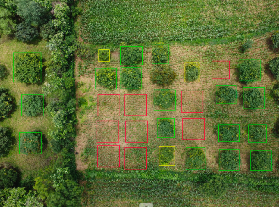
● This course introduces working professionals and students to tools that will help them process satellite and drone imagery, and create and overlay GIS maps on them. They will also be taught how to process these images and maps for analysing changes over space and time, such as water body encroachments, plantation casualties, and crop extents, using machine learning and participatory modelling methods.
● Self-certified computer literacy e.g. the ability to use word processing and/or Spreadsheet software well, is the only prerequisite for taking this course.
Live Sessions :
On all Wednesday's & Saturday's : 07:00 p.m. - 08:00 p.m.
Profile of the Instructor(s)
Prof. Abhijit P. Deshpande is a Professor of Chemical Engineering and co-PI of Rural Technology Action Group (RuTAG) at IIT Madras. He coordinated activities of RuTAG from 2018 to 2024. Among the technologies developed during this period are paddy thresher, automatic coir spinning machine, groundnut pod separator, madurkathi handloom mat weaving using electronic jacquard, vending cart, frugal hearing aid and mango seed decorticator. A fabrication/design platform that aims to enable local fabrication is also being developed.
Prof. Nagesh Kolagani is a Professor of Computer Science and Engineering at Saveetha School of Engineering, SIMATS, Chennai. He is an alumnus of IIT Madras: B.Tech. (1988) and Ph.D. (2016). He has 20+ years of experience in developing IT/GIS solutions for industry, Government, and villages working as Software Engineer in the USA, Project Scientist at IIT Madras, Associate Professor at IIIT Sri City, Head GIS at TNeGA, etc.
Prof. C. Lakshmana Rao is a Professor of Applied Mechanics at IIT Madras. He completed his B.Tech. and M.S. from IIT Madras in 1982 and 1986 respectively, and obtained his Ph.D. from MIT (USA) in 1992. He has a strong interest in development of frugal technological solutions for common problems encountered in rural areas: his most cited publication, together with Abhijit P Deshpande and M Bhaskar Rao, is: “Extraction of bamboo fibres and their use as reinforcement in polymeric composites” in Journal of Applied Polymer Science, 76 (1) : 83-92 (https://onlinelibrary.wiley.com/doi/10.1002/(SICI)1097-4628(20000404)76:1%3C83::AID-APP11%3E3.0.CO;2-L).
Module Details
MODULE - 1 : GIS Maps
Concepts Covered:
Introduction to GIS
Practice videos of QGIS and GeoODK
Learning Outcomes:
You will be able to create maps using QGIS, GeoODK and Google Earth
MODULE - 2 : Satellite Imagery
Concepts Covered:
Introduction to Remote Sensing
Practice videos of Google Earth
Learning Outcomes:
You will be able to create maps using QGIS, GeoODK and Google Earth
MODULE - 3 : Drone Imagery
Concepts Covered:
Introduction to Drone Imaging
Practice videos of WebODM and CVAT
Learning Outcomes:
You will be able to create ortho-mosaiced and annotated drone imagery using WebODM and CVAT
MODULE - 4 : Spatio-Temporal Analysis
Concepts Covered:
Introduction to spatio-temporal analysis
Practice videos with Google Earth Engine
Learning Outcomes:
You will be able to carry out spatio-temporal analysis using Google Earth Engine
MODULE - 5 : Machine Learning
Concepts Covered:
Introduction to Machine Learning
Practice videos with Google Colab & drone imagery
Learning Outcomes:
You will be able to monitor land use, plantations, crops, etc. using drone imagery & Machine Learning.
MODULE - 6 : Participatory Modelling
Concepts Covered:
Introduction to Participatory Modelling
Practice videos with System Dynamics
Learning Outcomes:
You will be model to model socio-economic systems using participatory methods.
Detailed plan
This course will start on September 2, 2024 and will run for twelve weeks, until November 24, 2024. Each week, the students will watch 3 videos, each about 20 minutes, on their own i.e. at their convenient time. They will submit a weekly assignment and work on related parts of a course project. They will also attend two 1-hour live sessions every week on all Wednesday’s and Saturday’s. These will review weekly course material and monitor student progress.
Eligibility
Computer Literacy: Skill in Using Word Processing and/or Spreadsheet Software(s)
Fees for the Workshop
Fees :
Students & Faculty : Rs 1180 (Rs 1000 + 18% GST)
NGO : Rs 1180 (Rs 1000 + 18% GST)
Government Organization : Rs 4720 (Rs 4000 + 18% GST)
Industry : Rs 11800 (Rs 10000 + 18% GST)
Certification
The criteria for the certificate is as follows:
Attendance
Assignments
Course Project
13 reviews for GIS, Drones and Machine Learning for Resource Mapping
Rated 5 out of 5
Prashant Singh (verified owner)–
The content is sufficient for an introductory course.
The assignments are easy. Some in the initial part of the course were exactly the same as what was covered in the class. Could have been slightly different.
Videos are needed. Slides would also help. Referring to the code is easier in slides. Some additional reference material especially the practical applications or case studies done at any of the IITs could have been the differentiator from so many courses available in the public domain.
The steps have been explained in detail, especially suitable from the introductory perspective.
The content and teaching methodology caters to a wide base of knowledge level of participants, especially with regards to coding.
The pace of the course suits the needs of working professionals.
Rated 4 out of 5
Deepika Bhardwaj (verified owner)–
Explaination is understanding and course is also knowledgeable.
Rated 5 out of 5
Deepika Bhardwaj (verified owner)–
It is totally worthy to opt for this course/workshop.
Rated 5 out of 5
monodip banerjee (verified owner)–
It’s an enjoyable and knowledgeable course. The live sessions are very much hand on exercise, clear almost every doubts. It’s understandable even non-codding background. Thank you NPTEL and respected sir for delivering such a great pice of knowledge.
Rated 5 out of 5
Dr. Dinesh Kumar S.P. (verified owner)–
It is one of the good course which I undergone. The live and interaction sessions are the best part of this course where we involve and learn more during this session. I request the NPTEL to provide printed/soft copy of manual for this course for future reference. Thanks to the team for conducting such a wonderful course.
Rated 5 out of 5
Kaleem Ashraf (verified owner)–
Course structure, videos, way of teaching and interaction-session really fruitful.
One request to NEPTEL team try to design another advance-course for GIS including GEE, QGIS and ML.
The ML portion can be a bit challenging for someone without a coding background.
Thanks for Prof. Nagesh Sir and NEPTEL team.
Regards,
Rated 5 out of 5
Shashikant Buvasaheb Gosavi (verified owner)–
Combination of Google Earth Pro with QGIS is nice to learn. All Demo sessions help us to learn basics as if its hands on trainig. Drone imageries made us to search and download was a good assignment. Assignments live sessions and projects are beautifully woven. The weekly sharing of videos and recorded live sessions helped for resolution of doubts. Professor Nagesh is punctual and fluent in sharing the knowledge. The live session time is good. Duration of live session is perfect. I learnt a lot and desirous of sharing with my students. A big thanks to IITM and NPTEL+ for creating excellent course for faculty,industry perslns and students.
Rated 5 out of 5
S. Eswari (verified owner)–
Respected Sir and NPTEL,
At the outset, I would like to thank for organising this course. Module framework is excellent. Dr. Nagesh sir stick on time to complete the scheduled framework. He clear all our doubts. His main aim is to make the participants more active by involving them in live session. He test our understanding. Make us to do Assignments and projects. The continuity of the course content released and live session discussion and hands on practice, helps us to follow and understand the content and task.
Thank you so much to Dr. Nagesh Sir and NPTEL (organising team).
Rated 5 out of 5
Stuthi Shrisha (verified owner)–
The course is very interesting, and is a good domain to apply ML concepts. I found the videos and the assignments engaging and I’m looking forward to applying these concepts in my future projects
Rated 5 out of 5
KRISHNAKUMAR V (verified owner)–
Respected Professor and the Team,
The course GIS, Drones, and Machine Learning for Resource Mapping, taught by Prof. Nagesh Kolagani through NPTEL. His teaching was exceptional, with thorough explanations that made complex topics accessible. He also addressed doubts with great clarity, ensuring all questions were resolved. Even during online classes, Prof. Kolagani maintained high teaching standards, keeping the sessions engaging and productive. This course has been highly insightful, and I greatly appreciate his dedication and expertise. The continuity of the course content released and live session discussion and hands on practice, helps us to follow and understand the content and task.
Thank you so much to Dr. Nagesh Sir and NPTEL (organising team).
Rated 5 out of 5
Devanshu Kashyap (verified owner)–
My experience with this course has been great. The content, live sessions and evaluation criteria are the best, suitable for all kinds of audiences which ensure that learning has happened. It is good to have applied projects and assignments instead of course-end examinations, it aligns well how learning and its implementation works in real life . As an addition you can include presentation-delivery from volunteering students(as an evaluation exercise) which can help other students to look at things from different angle and perspectives. The videos and live sessions do enough justice from effective learning point of view.
It will be nice to have pre-formative material and brief text notes for each week It helps in understanding things better. Also, it will be very beneficial to mention the areas and use cases where, whatever concepts we are learning are applied in real world problem scenarios along with jargon associated with subject and technology, because it helps in doing research.
Rated 5 out of 5
Prabhat Kumar Jena (verified owner)–
Best online course for students to professionals covering almost all sectors for the individual applications. Engineering, Geography, Geology, Transport analysis, Geoprocessing etc. Professor/Faculty of the course is very specific and teach line by line until one understands the purpose of the utilisation in terms of QGIS, GEE code,Python Code etc. Being a transport planner, I learned many ideas to implement in my sector.Thanks to NPTEL +
Rated 5 out of 5
Rama Kant Sharma (verified owner)–
I liked the teacher “Nagesh Kolagani” sir who has lots of patience and knowledge off course. He had taken care of the weakest students of the class along with everyone else.
Also, I got more practical idea about ML here. Previously, I was learning only theories. But now, I got more clearer picture about it.
Thanks a lot Nagesh sir and NPTEL.

Prashant Singh (verified owner) –
The content is sufficient for an introductory course.
The assignments are easy. Some in the initial part of the course were exactly the same as what was covered in the class. Could have been slightly different.
Videos are needed. Slides would also help. Referring to the code is easier in slides. Some additional reference material especially the practical applications or case studies done at any of the IITs could have been the differentiator from so many courses available in the public domain.
The steps have been explained in detail, especially suitable from the introductory perspective.
The content and teaching methodology caters to a wide base of knowledge level of participants, especially with regards to coding.
The pace of the course suits the needs of working professionals.
Deepika Bhardwaj (verified owner) –
Explaination is understanding and course is also knowledgeable.
Deepika Bhardwaj (verified owner) –
It is totally worthy to opt for this course/workshop.
monodip banerjee (verified owner) –
It’s an enjoyable and knowledgeable course. The live sessions are very much hand on exercise, clear almost every doubts. It’s understandable even non-codding background. Thank you NPTEL and respected sir for delivering such a great pice of knowledge.
Dr. Dinesh Kumar S.P. (verified owner) –
It is one of the good course which I undergone. The live and interaction sessions are the best part of this course where we involve and learn more during this session. I request the NPTEL to provide printed/soft copy of manual for this course for future reference. Thanks to the team for conducting such a wonderful course.
Kaleem Ashraf (verified owner) –
Course structure, videos, way of teaching and interaction-session really fruitful.
One request to NEPTEL team try to design another advance-course for GIS including GEE, QGIS and ML.
The ML portion can be a bit challenging for someone without a coding background.
Thanks for Prof. Nagesh Sir and NEPTEL team.
Regards,
Shashikant Buvasaheb Gosavi (verified owner) –
Combination of Google Earth Pro with QGIS is nice to learn. All Demo sessions help us to learn basics as if its hands on trainig. Drone imageries made us to search and download was a good assignment. Assignments live sessions and projects are beautifully woven. The weekly sharing of videos and recorded live sessions helped for resolution of doubts. Professor Nagesh is punctual and fluent in sharing the knowledge. The live session time is good. Duration of live session is perfect. I learnt a lot and desirous of sharing with my students. A big thanks to IITM and NPTEL+ for creating excellent course for faculty,industry perslns and students.
S. Eswari (verified owner) –
Respected Sir and NPTEL,
At the outset, I would like to thank for organising this course. Module framework is excellent. Dr. Nagesh sir stick on time to complete the scheduled framework. He clear all our doubts. His main aim is to make the participants more active by involving them in live session. He test our understanding. Make us to do Assignments and projects. The continuity of the course content released and live session discussion and hands on practice, helps us to follow and understand the content and task.
Thank you so much to Dr. Nagesh Sir and NPTEL (organising team).
Stuthi Shrisha (verified owner) –
The course is very interesting, and is a good domain to apply ML concepts. I found the videos and the assignments engaging and I’m looking forward to applying these concepts in my future projects
KRISHNAKUMAR V (verified owner) –
Respected Professor and the Team,
The course GIS, Drones, and Machine Learning for Resource Mapping, taught by Prof. Nagesh Kolagani through NPTEL. His teaching was exceptional, with thorough explanations that made complex topics accessible. He also addressed doubts with great clarity, ensuring all questions were resolved. Even during online classes, Prof. Kolagani maintained high teaching standards, keeping the sessions engaging and productive. This course has been highly insightful, and I greatly appreciate his dedication and expertise. The continuity of the course content released and live session discussion and hands on practice, helps us to follow and understand the content and task.
Thank you so much to Dr. Nagesh Sir and NPTEL (organising team).
Devanshu Kashyap (verified owner) –
My experience with this course has been great. The content, live sessions and evaluation criteria are the best, suitable for all kinds of audiences which ensure that learning has happened. It is good to have applied projects and assignments instead of course-end examinations, it aligns well how learning and its implementation works in real life . As an addition you can include presentation-delivery from volunteering students(as an evaluation exercise) which can help other students to look at things from different angle and perspectives. The videos and live sessions do enough justice from effective learning point of view.
It will be nice to have pre-formative material and brief text notes for each week It helps in understanding things better. Also, it will be very beneficial to mention the areas and use cases where, whatever concepts we are learning are applied in real world problem scenarios along with jargon associated with subject and technology, because it helps in doing research.
Prabhat Kumar Jena (verified owner) –
Best online course for students to professionals covering almost all sectors for the individual applications. Engineering, Geography, Geology, Transport analysis, Geoprocessing etc. Professor/Faculty of the course is very specific and teach line by line until one understands the purpose of the utilisation in terms of QGIS, GEE code,Python Code etc. Being a transport planner, I learned many ideas to implement in my sector.Thanks to NPTEL +
Rama Kant Sharma (verified owner) –
I liked the teacher “Nagesh Kolagani” sir who has lots of patience and knowledge off course. He had taken care of the weakest students of the class along with everyone else.
Also, I got more practical idea about ML here. Previously, I was learning only theories. But now, I got more clearer picture about it.
Thanks a lot Nagesh sir and NPTEL.