This course introduces learners to technologies that will help in:
1) Creating GIS maps
2) Using satellite & drone imagery to enhance these GIS maps
3) Modelling real-world problems and potential solutions using the System Dynamics tools
Live Sessions :
On all Wednesdays & Saturdays: 07:00 p.m. – 08:00 p.m.
Prof. Nagesh Kolagani is a Professor of Computer Science and Engineering at Centurion University of Technology & Management (CUTM), Vizianagaram, AP. He is an alumnus of IIT Madras: B.Tech. (1988), Ph.D. (2016). He has 25+ years of experience in developing IT/GIS solutions for industry, Government, and village stakeholders. He worked earlier as: Software Engineer at Borland Corporation (CA, USA), Project Scientist at IIT Madras, Associate Professor at IIIT Sri City (AP), Head GIS at TN e-Governance Agency, etc.
Prof. Abhijit P. Deshpande is a Professor of Chemical Engineering and co-PI of Rural Technology Action Group (RuTAG) at IIT Madras. He coordinated the activities of RuTAG from 2018 to 2024. Among the technologies developed during this period are the paddy thresher, the automatic coir spinning machine, the groundnut pod separator, the madurkathi handloom mat weaving using electronic jacquard, the vending cart, the frugal hearing aid, and the mango seed decorticator. A fabrication/design platform that aims to enable local fabrication is also being developed.
Module Covered
MODULE - 1 : GIS Maps
Concepts Covered:
Introduction to GIS
Practice videos of QGIS and GeoODK
Learning Outcomes:
You will be able to create maps using QGIS and GeoODK
MODULE - 2 : Satellite Imagery
Concepts Covered:
Introduction to Remote Sensing
Practice videos of Google Earth
Learning Outcomes:
You will be able to create maps using Google Earth images as background
MODULE - 3 : Drone Imagery
Concepts Covered:
Introduction to Drone Imaging
Practice videos of WebODM and QGIS
Learning Outcomes:
You will be able to create ortho-mosaiced and annotated drone imagery
MODULE - 4 : Participatory Modelling - Basics
Concepts Covered:
Introduction to Participatory Modelling - Practice videos with System Dynamics: Causal Loop Diagrams
Learning Outcomes:
You will be able to model socio-economic & other systems using System Dynamics
The course allowed knowing about the latest tools in GIS and spatial data analysis, and learn the concepts with a hands-on approach
The students gained valuable insights into the practical aspects of Spatial data, especially Drone imaging and analysis
The course videos and the steps were sufficient to cover the topic and to perform the task. The live sessions were adequate to explain the concepts and give demos.
We were fortunate to have professor Kolagani as a faculty for the course who guided us throughout with lot of patience.
Live sessions are very well handled by the faculty. He explains everything from scratch and helps us solve assignments
Detailed Plan
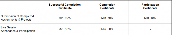
This course will start on the 4th of August, 2025, and will run for twelve weeks, until the 26th of October, 2025. The learners will: 1) Watch videos 2) Submit assignments and projects 3) Attend and participate in 1-hour live sessions on Wednesdays and Saturdays
Reviews
There are no reviews yet.
Be the first to review “GIS, Satellite & Drone Imagery for Resource Mapping” Cancel reply

Reviews
There are no reviews yet.